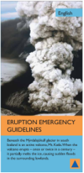
Katla's Hazards
Local risks to population and economy
|
Iceland has harsh weather and the majority of casualties on the island country are attributed to weather-related events such as storms, blizzards, heavy seas, and snow avalanches. However, although the death toll is smaller for volcanic events historically, eruptions have clamed the most lives in a single event directly or indirectly (flood or famine) (5)
Ash and TephraThe ash and tephra emitted by the 2010 eruption of Eyjafjallajökull grounded most of Europe’s air travel and changed the world’s climate temperature a full degree. Icelandic eruptions such as Eyjafjallajökull became a major problem to Europe if the North westerly airflow between Iceland and North West Europe is prevailing (around 6% of the year). However, the devastation felt by the Eyjafjallajökull eruption would be completely eclipsed by a Katla eruption which is estimated to be more than ten times greater than that of Eyjafjallajökull. (12)
|
Jökulhlaups - glacial outburst floods
Jökulhlaups are the most common hazard related to volcanic and geothermal activity in Iceland. When the Ice over the volcano melts due to the heat produced by the volcano, it causes water to form a lake under the remaining ice cap. When the ice cap then collapses into the lake or the water breaks through the barriers containing it, a type of lahar called a jökulhlaup rages down the mountain slopes carrying with it ice blocks the size of houses. (6) These water flows often carry a heavy load of sediments and ice blocks but when floods are considered more debris flows than glacial outburst floods, they are called lahars.(5)
Other hazardsOther infrequent or minor hazards include earthquakes, faulting, damming of rivers by lava flows or tephra and tsunamis. “The plume of volcanic material thrown up by Katla is highly conductive and there is a risk of lightning strikes within a radius of 30-40 km from the volcano.” (2)
*Katla has historically only taken the life of one person directly (not counting floods) since 1500 AD. During an eruption in 1755, the victim was truck by lightning 35 km from the volcano (5)*
|
Current monitoring activities
|
“The great hazard posed by Katla has led to special monitoring with seismometers, continuously recording GPS, radio-linked river gauges, regular airborne radar profiling and inspection fights of the icecap” (5) |
Since settlement time, around 874ad, Katla has erupted at least 20 times. (11) Thanks to advancing technology, early warning systems are in place using seismic stations on all active volcanoes in Iceland. (5) The Icelandic Meteorological office maintains the continuous GPS (CGPS) networks on katla to follow real-time seismicity and crustal deformation at katla. (5)
|
Proposals for how risk posed can be minimized
|
Historically, Katla jökulhlaups have been preceded by earthquakes 2-10 hours before floodwater emurges from glacier. In the eruption of 1918, 300,000 m3/s of water flowed from the eruption. Short warning systems give civil defense 1 to 2 hours to close roads and evacuate the 600 lives at risk. Large Katla jökulhlaups have flowed toward the west once every 500 to 800 years. (5) Most jökulhlaups go south or east and though the risk can not be abolished, evacuation routes can be practiced and known so people in the area can get out of the way when danger comes.
|
“When it has been confirmed that katla has started to erupt, warnings are passed to all the main tourist venues in the region. During the summer season, land wardens at the major mountain cabins in the risk area will fire maroons (which will explode with a loud bang) and flares to warn travelers in the region. The warning signal for an eruption is five maroons and five flares. The signal is repeated twenty minutes later…If an eruption warning signal is given, keep to the upper slopes.” (2) |